Rather than start somewhere in the middle I feel my first blog should at revolve around some compelling evidence for advanced civilisation existing long before current accepted theories.

Athanasius Kircher's map of Atlantis, in the middle of the Atlantic Ocean. From
Mundus Subterraneus 1669, published in Amsterdam. The map is oriented with south at the top.
In 2001 a librarian named Rand Flem Ath introduced a new theory to the world in his book, The Atlantis Blueprint. Inside amongst other things Rand asserted that by shifting the prime meridian from its current position at Greenwich and positioning it at Giza in Egypt the world suddenly took on a very different identity.
Marking up a map of the modern world into a grid with Giza as the Prime Meridian he was surprised how many sites of religious importance lay at ten degree intervals from the Giza Pyramids. Easter Island lies 140 degrees west; the pyramids at Teotihuacan and Tula (sacred city of the Toltecs) in Mexico are positioned at 130 degrees west; the pyramids at Copan and Quirigua (also in Mexico) can be found 120 degrees west; Quito, the northern capital of the Inca Empire, is 110 degrees west; and the Gateway to the Sun at Tiahuanaco lies 100 degrees west of the Great Pyramid. To the East, the great Ziggurat at Ur lies exactly 15 degrees east; and Lhasa, the capital of ancient Tibet, lies 60 degrees east of the Great Pyramid. This is not an exhaustive list and many more sites are identified in the book.
As pleased he was with his findings a number of significant sites such as Stone Henge and didn’t seem to fit the theory and he realised he must be missing something. It was then that Rand’s second big breakthrough occurred when he substituted magnetic north for a previous incarnation. You may or may not know that as a result of Earth Crust Displacement magnetic North has not been a constant during Earth’s history; a fact substantiated and logged by Geologists studying volcanic rock. The temperature of molten rock is above the curie temperature of any ferrous oxide it may contain which therefore means that during an eruption the rock gets so hot that any magnetism present within it simply resets. As the rock cools, the ferrous oxides inside it regain their magnetic properties and, unlike other rock types, they will then hold onto these properties until the end of time. Essentially therefore, volcanic rocks can give you a very accurate reading of the whereabouts of magnetic north at the precise time of their respective eruptions. Scientists know that magnetic north has switched twice in the last 100,000 years; moving approximately 80,000BP from its position in the Yukon Valley to the Hudson Bay and then moving again sometime around 12,500BP to its present coordinates.
This brings in a whole new set of Rand’s ‘sacred’ sites into the equation; sites such as Jericho/Jerusalem and Stone Henge now fitting into his theory as having latitudes of 5 and 30 degrees respectively when recalculated using the ancient poles.
In carrying out his research he also discovered that when they were constructed, a number of ancient sites around the world had been aligned to reflect the positions of these obsolete poles. The avenue of the dead at the site of Teotihuacan in Mexico, for example, was orientated and aligned using the Hudson Bay pole.
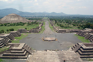
The Avenue of the Dead at Teotihunacan.
This alone points to an understanding of both science and geography during the Neolithic era that our ancestors have not been credited with. How could the inhabitants of a settlement established around two thousand years ago have possibly been party to the co-ordinates of magnetic north as it was ten thousand years previously? This is not the only example and these alignments crop up at other sites including Tula, Copan and Xochicalco.
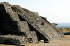
Stepped Pyramid at Tula archaeological site
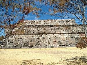
Temple of the Feather Serpent at Xochicalco
The anomaly also appears outside of the Americas and at the site of Ur it is clear that both its stepped pyramid and shrine to the moon god have both been aligned with the Hudson Bay Pole.

Reconstruction of Ur-Nammu's ziggurat, based on the 1939 reconstruction by Woolley (vol. V, fig. 1.4)
Rand believes that the Atlanteans established settlements on these ‘sacred’ sites which accounts for why so many of them still retain this status. In my opinion it is more likely that these early cartographers placed some kind of marker down which was later interpreted by the indigenous population as other worldly and revered as such. Either way I feel this is a compelling starting point for arguing that advanced civilisation existed at a time when current archaeology still has humanity scavenging for scraps in small groups all around the world. If it could be proven that man accurately mapped the Earth as much as 80,000 years ago, it would certainly blow all current archaeological theory as to the origins of civilisation completely out the water.
Current Theory - The Orgins of Civilisation in the Ancient Near East (Wikipedia)
The Ancient Near East is considered the cradle of civilisation. It was the first to practice intensive year-round agriculture; it gave the rest of the world the first writing system, invented the potter's wheel and then the vehicular- and mill wheel, created the first centralised governments, law codes and empires, as well as introducing social stratification, slavery and organised warfare, and it laid the foundation for the fields of astronomy and mathematics.
| Name | Period | Area | Occupations | Writing | Religion |
|---|
| Indus Valley Civilization- Harappa / Mohenjo-daro | 3000 – 1500 BC | Northwest India, Pakistan, | Potter's wheel, Agriculture, dams, city planning, seals | Pictographic | Unknown |
| Mesopotamian | 3000 – 750 BC | Sumer, Babylonia, Assyric Highlands | Dairy farming, textile, metal working, potter's wheel, sexagesimal system | Cuneiform | Polytheistic |
| Egyptian | 3000 – 800 BC | North Eastern Africa along River Nile | Egyptian Pyramids, Mummification, Decimal system, Solar calendar | Hieroglyphic | Polytheistic |
| Chinese | 1600 BC – 1 AD | China | Silk, Pottery, Chinaware, Metals, Great Wall, Paper | Chinese | Taoism, Confucianism |
| Persian | 730 BC | Greater Persia | Agriculture, architecture, landscaping, postal service | Cuneiform, Pahlavi | Zoroastrianism |
| Greek | 2700 BC - 1500 BC (Cycladic and Minoan civilization), 1600 BC – 1100 BC (Mycenaean Greece), 800 BC (Ancient Greece) | Greece (Peloponnese, Epirus, Central Greece, Western Greece, Macedon), later Alexandria | Agriculture, winemaking, architecture poetry, drama, philosophy, history, rhetoric, mathematics, political science, astronomy, physics, chemistry, Medicine | Greek | Polytheistic |
| Roman | 600 BC | Italy | Agriculture, Roman calendar, concrete | Latin | Polytheistic |
| Mayan | 1500 BC – 300 AD | Central America | Agriculture, cotton, dyeing, Mesoamerican pyramids | Hieroglyphic | Polytheistic |
| Aztecs | 1325 AD – 1519 AD | Mexico | Agriculture, smelting, metal working | Pictographic | Polytheistic |
| Incas | 1300 AD – 1532 AD | Ecuador, Peru, Chile | Textile looms, agriculture, Inca architecture | – | Polytheistic |